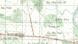
One key to survival in Vietnam was the ability to find your way home
again. Our first tools were the map and compass. The Army developed a special
colored, topographical pictomap. It was based on photographs of the terrain and
showed all of the buildings, forests and fields, the rice dikes and bodies of water.
Everything was color-coded to its true colors, and elevation lines gave the
relative altitude of the terrain. Using these, and the lensatic compass to determine
direction, we could usually figure out where we were going, and where we had been.
 Still,
it wasn't always as easy as just looking at the map. No matter where you were, most
of the countryside looked the same. If we entered a village, there was not much to
distinguish it on the map from other villages, for it was just a cluster of little black
squares. If we had happened to level a few of those hootches during a firefight,
then the map had no relationship at all to the actual layout. Likewise one set of
rice paddies looked pretty much like all the rest when seen from an elevation of about six
feet. No matter where we were, the trees on the horizon seemed to encircle us,
however far away they were. The trees close up concealed the ones farther
away. There was a complete absence of distinguishing landmarks in most places. So if
we had relied on nothing but the maps, we'd have been lost much of the time.
To compensate for this lack of reliability, we kept track of the distance we traveled.
One or two men were responsible for counting the number of steps we took.
Some guys just kept track in their heads, and others counted on their fingers. One
sensible man I knew used a piece of string. He made a knot for each hundred steps he
took, or for each one hundred yards. To find out how far we had walked he added up
the knots and multiplied by one hundred. It was usually pretty close. Knowing
the direction we had walked by compass, and the distance from our count, we could
calculate the return azimuth and distance.
Once in a while even this simple method failed. When we got into a fight even the
most experienced counter sometimes forgot to keep track of the count. Or didn't know
how to add in the extra yards for the giant steps we took retreating in the opposite
direction. When this happened we relied on artillery to help us out. It was
one of the few times the artillery lieutenant, assigned as a forward observer for the
artillery battalion supporting us, got a chance to strut his stuff. He took the
radio handset from his sergeant, spoke a few arcane sentences into it, and voila!, within
a minute or two a resounding Boom! filled the air and a bright white cloud appeared in the
sky. A white phosphorous airburst. Artillery could tell us exactly what map
grid they had fired into, and by checking the direction to the smoke from our present
location we could tell where we were. The only flaw in this technique was that you
wanted to be very sure the location of the burst was in a quadrant other then your own!

East Is East And West Is West: Tales Of A War Far Away
Copyright © 1995 Kirk S. Ramsey
Last modified:
March 02, 1995
